
Designed to provide insights into the water sector.
See upcoming webinars by clicking below...
Led by industry experts in real-time sessions, our live online training courses provide a platform for active engagement. Interact with instructors and fellow participants, pose questions, and collaborate on hands-on exercises to enhance your practical skills.
With no fixed schedule, you have the flexibility to choose from a diverse range of topics designed to meet your learning needs. Accessible at any time, these courses feature pre-recorded content delivered by industry experts in the water sector.
Explore modern flood frequency analysis with Bayesian inference, nonstationarity, and peaks-over-threshold using RMC-BestFit.
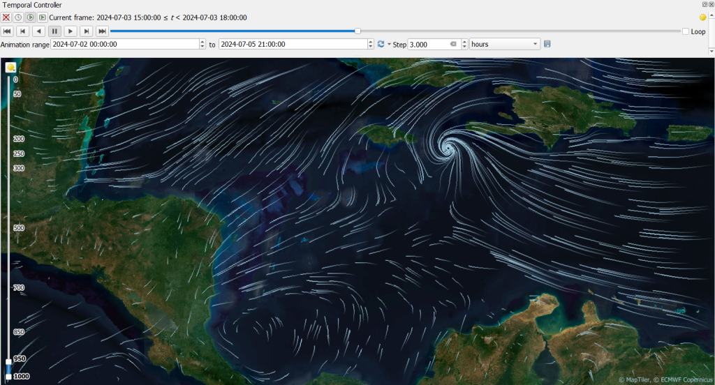
Do you want to learn how to work with mesh data in QGIS? Join the upcoming course Mastering Mesh Data with
QGIS taught by Hans van der Kwast and Kurt Menke.
Mesh data is fundamental to hydrologic, hydraulic, oceanographic, meteorological, and environmental modelling. But working with meshed datasets can be complex - until now!
Join us to gain expertise in mesh data formats, including NetCDF, using QGIS. Learn to create, edit, and apply mesh data, unlocking powerful geospatial analysis and visualisation tools.
This course is perfect for water industry modeller and GIS professionals working with a range of modelling platforms to enhance your skills and streamline your workflows.
What you’ll learn:
- QGIS for Mesh Data: Unlock the full potential of QGIS to analyse, visualise, and animate your mesh data with precision.
- Real-World Applications: Mesh data for hydrologic, hydraulic, oceanographic, meteorological, and environmental modelling.
- Diverse Modelling Platforms: Apply meshing tools to HEC-RAS 2025, TUFLOW, OpenFOAM, and any other modelling platforms.
Register now and start your training today!
This two session course will explore pipe network modelling capabilities in the newly released HEC-RAS Version 6.7. Attendees will work with a pre-built 2D overland flow model as the foundation for their workshop exercise. During the sessions, attendees will construct a subsurface pipe network, assigning geometric and geospatial attributes to nodes and conduits.
The course covers essential techniques for importing data and selecting appropriate modelling parameters for pipe networks. Upon completing the exercise, attendees will learn how to interpret and troubleshoot model results effectively.
Additionally, the course includes resources for those interested in exploring the new meshing options available in HEC-RAS 2025.
Ideal for engineers, water modellers, and professionals seeking to enhance their expertise in HEC-RAS, this course delivers practical skills and insights to elevate your modelling capabilities.
